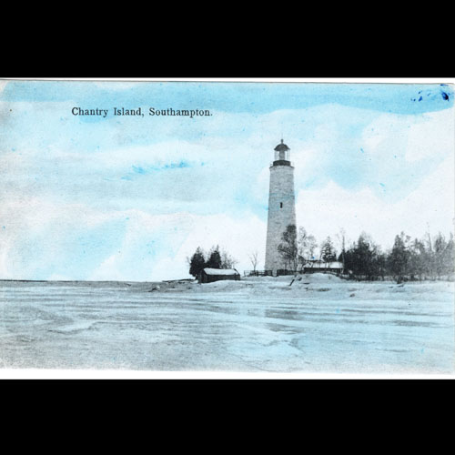
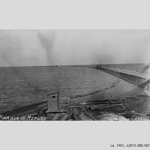
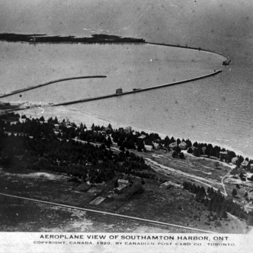
If you take a tour to the top of Chantry Island Lighthouse (https://chantryisland.com/) and look across the lake towards Southampton, you may see shadows under the water, curving through the lake between Chantry Island and Southampton’s shoreline at the foot of Beach Street, similar to the aerial photo in the slideshow above. These shadows are cast by remnants of the former “Island Dock” and “Long Dock” piers, which formed Southampton’s Harbour of Refuge. You may also notice the red and green buoys on Lake Huron which continue to mark the way of safe passage past the boulder remnants and through the gap between the former piers.
These breakwater piers were built by the Federal Government, between 1871 and 1877, to create a “Harbour of Refuge” for vessels caught in storms along this shore, with a 122 m (400 ft) gap between the two piers forming the harbour entrance on the north side.
The construction of these piers was supported by information contained in reports such as the 1865 federal report, “Report by Walter Lawson on the Harbors of the County of Bruce”, which stated, “The coast of Bruce, except on the extreme northern portion, … is remarkably destitute of natural harbors and of inlets, capable of being converted into safe commercial harbours. The only places that can be said to possess natural advantages worth mentioning, are Southampton and Inverhuron …” The report recognized Kincardine and Southampton as “chief centres of trade” and recommended that government funds be applied at those two places.
Island Dock
A place of refuge for ships began with the pier known as the “Island Dock”. The pier extending from the northeast end of Chantry Island is mentioned as early as December 1856 (before completion of the Chantry Island Lighthouse) in a Federal Commissioner of Public Works report: “The work of the break-water pier at Chantrey [sic] Island … is complete. The amount of shelter and other benefits already derived from it, although carried out to a very limited extent, establishes the fact beyond doubt that if an additional length of from 1,000 to 1,500 feet of breakwater is constructed, a most valuable and capacious asylum would be created, for which vessels engaged in trade on that otherwise very much exposed coast could run in stress of weather.”
Part of the Island Dock washed away in 1861, and in 1865 it was extended to 198 m (650 ft.) In 1871, the Island Dock was once again extended to reach almost 695 m (2,280 ft), setting the stage for the construction of the Long Dock and the formation of the Harbour of Refuge.
Long Dock Construction & Island Groyne
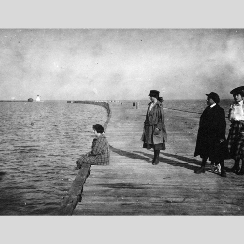
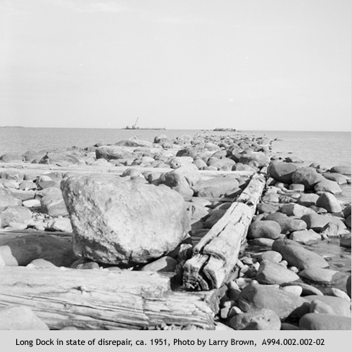
As the photos in the slideshow above show, the Long Dock was quite a sight! The pier measured 610 m (2,000 ft) long and was an average of 7.5 m (25 ft) wide. It rose to a height of about 2.3 m (7.5 ft) above the water line, well over the heads of most beach-goers. Imagine walking more than half a kilometer into Lake Huron!
Construction of the Long Dock began in 1873 and its foundation consisted of a series of 30-foot square wooden cribs made of massive timber and filled with stone. A colourful description of progress on the Long Dock construction appeared in “The Globe” on Tuesday, August 24, 1875:, “The quantity of lumber used is enormous, and stone enough to build the Chinese wall or the Tower of Babel has been sunk and held by these enormous cribs. … next season will no doubt see fully completed the best harbour on the Canada shore of Lake Huron.”
Upon its completion in 1877, the 122 m (400 ft) entrance gap, between the long and island docks, was often crossed by strong currents. To find the entrance, ships would line up the light cast from a gas buoy to the north, with the range light on the tip of the Island Dock, and with another range light on McNabb Point, located on the mainland to the south, north of Horseshoe Bay.
Later, a groyne was added on a smaller scale extending southeasterly from the Island to protect against south winds.
At the peak of the lake shipping era in Southampton, the harbour was extremely busy with schooners.
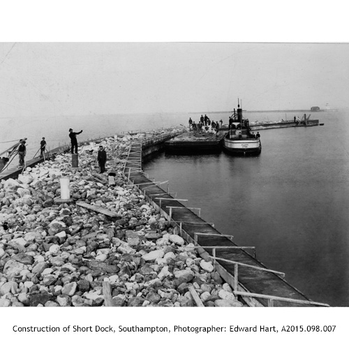
Short Dock
The slide show above also features an image of the construction of a third pier, known as the “Short Dock.” The pier also appears in the aerial image, extending from the mainland just south of the Long Dock. The Short Dock was the site at which ships would unload their cargo; a railway spur line ran along it for that purpose.
Storms and Accidents at Harbour Entrances
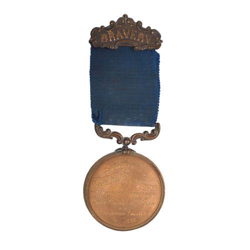
Although the Harbour served as a place of refuge for many ships during storms, safe entrance was not guaranteed! Although Chief Engineer H.F. Perley recommended Chantry Island as one of the best sites for a harbour of refuge in January 1870, Inverhuron was also suggested by a Royal Commission as a natural and safer place for such a harbour, due to its lack of the natural dangers surrounding Southampton and Chantry Island. It is impossible to enter the Southampton harbour from the direct west due to the Island, nearby large rocks, and the reef which runs along the north and south sides. Entering from the south requires navigating around a reef, often in a driving wind. Entering from the south requires navigating around a reef, often in a driving wind. The 24-year old, 103-ton scow “Mary & Lucy” discovered the dangers of the southern approach during a heavy gale on September 4, 1879 while delivering lumber from Midland to Goderich. They became stranded on the south reef of Chantry, and the gale blew the ship over the reef and into the shallows of the mainland beach. The crew survived; however, Ross Lambert, son of the Chantry Island lightkeeper, drowned during the rescue attempt. The underwater wreck remains discoverable in the vicinity today.
The narrow northerly approach through the Gap was also very hazardous in a storm, as demonstrated by the “Erie Stewart” whose remnants you may also still see submerged at the harbour’s former entrance. In October 1907, the two-masted schooner “Erie Stewart” destroyed the Island Dock range light as it tried to enter the harbour during a fierce storm. The gas buoy light was not working, and the rear range light on McNabb Point was clouded by the gale and rain. Battered by waves and unable to align with lights not seen, the ship hit the Island Dock about 90 m short of the entrance. The crew jumped onto the dock, but “Erie Stewart” was dragged by the wind and waves toward the gap, tearing out the top of the dock and crashing its foremast into the range light. The crew usef row boats next to the range light to row through the Harbour of Refuge to the Chantry Island Lighthouse.
Another unfortunate accident occurred the same stormy night. After the range light had been destroyed, the schooner “Ontario”, guided by Southampton’s Capt. Frank Granville, attempted to enter the Saugeen River Harbour instead of the Harbour of Refuge due to its lack of lights as navigational aids. Unfortunately, she ran aground on a sandbar just south of the river mouth. The crew waded ashore, but the waves continued to crash into the schooner which was a total loss.
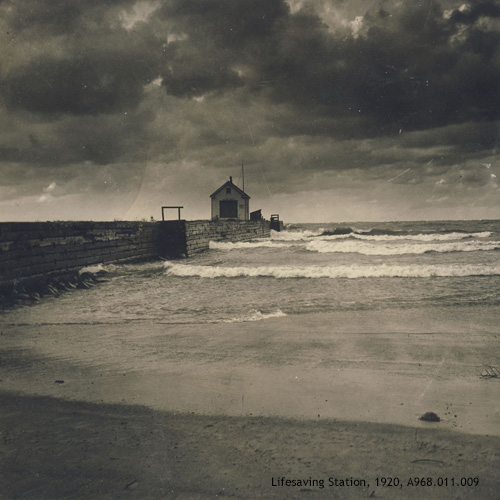
Life-Saving Station
With
disasters like those mentioned above, it is not surprising that a lifesaving
station was desired at Southampton! The
Government Life-Saving Station, originally constructed in 1908 on the
Southampton shoreline just north of Palmerston Street, was moved onto the
Long Dock in 1918, remaining there until its closure in 1937. (It was re-located to Beach Street
where it now serves as a cottage.) An
image of the station on the Long Dock is part of the slideshow above.
Recreation
The Harbour of Refuge not only served as a refuge for ships; it served as a recreation site for Southampton residents and visitors as well! People enjoyed the Long Dock for strolling and fishing. The Harbour provided a sheltered location for outdoor swimming lessons, with two diving boards eventually situated on the Short Dock. The senior class practiced swimming between the docks, a distance longer than officially required, resulting in excellent scores on their swimming exams! Swimming lessons continued to be offered in the Harbour area until the late 1970s using a raft anchored off-shore after the docks and diving boards were gone.
Deterioration
The piers’ condition gradually deteriorated and in 1923, a public meeting was called for residents to decide between repair of the Harbour of Refuge piers or the Saugeen River Harbour. It was decided to repair the River Harbour. By 1936, the Long Dock was in dire state of repair as noted in “The Beacon” on August 27: “Numerous fires and the action of the elements have played havoc with the dock until it has now reached the point that is dangerous for people to use it. Since the government has abandoned the harbour, no repair work has been done, and the dock has gradually become worse.” In 1943 part of the Long Dock washed away in fall storms and in 1946 the Federal Department of Public Works removed timbers and stones near the shore using a bulldozer. In 1951 the “Southampton Beacon” reported that another storm had reduced the remaining dock to a “pile of rubble.”
Take A Step Back in Time
Although only remnants remain, we can still imagine ourselves strolling down the Long Dock admiring ships in the harbour. Visit the Bruce County Museum & Cultural Centre’s third floor “Culture Cube” to snap a photo of yourself standing on the Long Dock.